
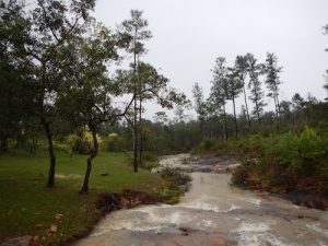
🌊 Explore Waterfalls, Natural Pools & Hidden Gems
On this Belize waterfall tour, you’ll visit some of the most beautiful spots in the region, such as:
Refreshing natural swimming areas
Scenic jungle viewpoints
Unique rock formations and caves
Peaceful forest trails perfect for nature lovers
The Mountain Pine Ridge area is one of Belize’s top eco-tourism destinations, making it ideal for travelers looking for things to do in San Ignacio Belize.
🧭 Why Choose This Pine Ridge Tour?
- ✅ Professional local guides with expert knowledge
- ✅ Small-group experience for personalized service
- ✅ Perfect blend of adventure and relaxation
- ✅ Easy access from San Ignacio and surrounding areas
- ✅ One of the most popular Belize inland tours
⏱️ Pine Ridge Tour Itinerary
- Departure Time: 8:00 AM
- Duration: Full-Day Tour
- Return in the late afternoon after a full day of exploration
👕 Dress Code for Pine Ridge Tour
- Wear light, comfortable clothing
- Use adequate footwear (water-friendly recommended)
- Be prepared for clothing to get wet
🎒 What to Bring for Your Belize Adventure
- Camera 📸 (perfect for waterfalls & nature shots)
- Bug spray 🦟
- Sunscreen 🌞
- Drinking water 💧
- Towel
- Extra clothing for after swimming.
📍 Book Your Pine Ridge Tour Today
Looking for the best Belize jungle tour or waterfall experience near San Ignacio? Book your Pine Ridge adventure with Jam Jam Tours today and explore one of Belize’s most beautiful destinations.
